Gritstone Landscapes in the Peak District
The northern Peak District is bounded on east and west sides by sandstone scarps : known as "Edges". They are made of a rock generally called "Millstone Grit". This is in fact a catchall for a variety of coarse sandstones, referred to here as "grits". Grits were laid down in the delta of an immense river which flowed from a mountainous area which once 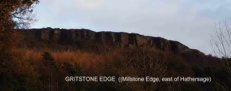 existed to what is now the northeast of England. The land was below the sea, and every tide, every flood, dumped sand onto the sea floor. Generally the layers were thin and/or disturbed by currents. Occasionally some event would occur which laid down layers many metres thick in a very short time. All this happened around 300 million years ago, long before the dinosaurs. Eventually the grits were buried by muds, coal, and limestones. The layers of sand, under pressure and subject to chemical change, became rock. Eventually what is now England was pushed up out of the sea and erosion began. A long and complex story can be reconstructed today by studying the geology of the Peak District.
existed to what is now the northeast of England. The land was below the sea, and every tide, every flood, dumped sand onto the sea floor. Generally the layers were thin and/or disturbed by currents. Occasionally some event would occur which laid down layers many metres thick in a very short time. All this happened around 300 million years ago, long before the dinosaurs. Eventually the grits were buried by muds, coal, and limestones. The layers of sand, under pressure and subject to chemical change, became rock. Eventually what is now England was pushed up out of the sea and erosion began. A long and complex story can be reconstructed today by studying the geology of the Peak District. One aspect of this are the gritstones. Some layers of gritstone technically known as "Rivelin Grit" and "Chatsworth Grit", were often laid down in ways which have left uniform rock, free of lines of weakness. They outcrop on famous rock climbing Edges such as Stanage, Curbar and Gardoms near Sheffield, and at the Roaches on the Staffordshire (west) side. Rocks free of natural lines of weakness are a kind of "freestone" to a mason - a material which can be worked in any direction. These are the layers worked for centuries to produce querns and millstones to grind cereals such as wheat and barley. Milling requires sharp surfaces to tear open, rather than crush, tough grains, and the quartz (sand) grains of Peak District Grits do just that. Grit continues to be quarried for building stone and examples can be seen near the fountains in Sheffield city centre.
click below for
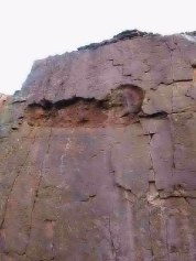
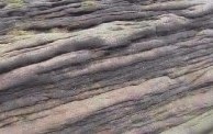 Gritstone appears in many forms. In the quarry face to the right, the lower area is largely free of layering - lines of natural weakness. It may have been created when one great flood dumped the whole layer on the sea floor in one episode. The hollowed out area in the photo on the right is chemical weathering - a layer where minerals have migrated through the rock, leaving a friable, easily eroded band. On Stanage Edge, this process - little understood - created "Robin Hood's Cave"- a series of small rounded caves in the otherwise angular gritstone. Most grit does contain strata, however and boulders and tors exposed to the weather for long periods often have the joins between layers of deposition picked out. Each unit represents the layer of grit laid down in one episode - probably just one tide, perhaps an annual flood, perhaps a once a century event - no one is sure.
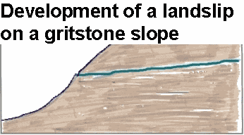
OK - how does all this affect the landscapes we see? At the most basic level, because grit is strong, it tends to form the highest ground. Because it is has highly variable layers, it tends to form cliffs - Edges - when the erosion of weak layers undermines stronger material above and the resultant overhang breaks off. A variation on this occurs where shales layers interleave grit or similar sandstones. Shales, though weak, tend to be a barrier to ground water and channel water to spring lines. Landslips occur when blocks of grit slip on the weak and wet grit-shale boundary.
Lud's Church (Grid Ref: 987657) is an excellent example of a partial landslip -blocks of grit have slipped downhill but have not rotated. The result is a deep chasm in the hillside. Much the same process created the "castles" at Alport Castles.
|
The most famous (and biggest) landslip in the Peak is at Mam Tor, but this is mostly developed in shales. There are many landslips around the edges of Kinder Scout and Bleaklow which have developed as described above. (See diagram at the bottom of this page)
Where gritstones has been eroded in plateau areas, tors develop. The exact origin of tors (such as Mother Cap just north of the Surprise View car park), is not clear, but seems likely to be due to the rotting of thick layers in a warm wet climate. Occasionally, particularly hard cores remained unaffected. Wind and rain have since removed all the loose, rotted material, and left the tors behind. Wind erosion, probably particularly severe in the intensely cold, dry conditions which prevailed over Derbyshire during the last Ice Age, have them picked out weak layers and scoured out the sculptured features we see today,
A process which is still active today (sometime visible on old gritstone gate posts etc.) is the development of crenellations in pinnacles of gritstone. These are vertical flutes which are at their deepest near the top of exposed features, and run vertically down, irrespective of the angle of the local strata, but gradually fade after a metre or two. The classic examples of this can be seen at Robin Hood's Stride near Birchover, but in can be seen on unquarried Edges too. Erosion is clearly due to rain running down the exposed rock, but the mechanism is unclear - erosion is greatest where the volume of water running down the rock is least and vice versa. It is likely that minerals are being transported by water moving through the pores in the rock in such a way that vertical lines of weakness develop.
Buy "Classic Landforms of the Dark Peak" book from the Geographical Association or Amazon:
Copyright @ 2003 Stephen N.Wood. All rights reserved.
http://www.together-now.co.uk/
This is a Web Counter
This page has been accessed