Limestone Landscapes in the English Peak District
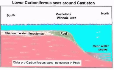
Limestone is formed from the remains of billions of tiny shells and skeletons. Most of these decayed totally 300 million years ago, but a few decayed only partially. Those which decayed least are visible to the naked eye as fossils, others can only be recognised with a microscope. Limestone is essentially calcium carbonate plus a few  impurities. It is a material that can exist in a variety of forms - the lime scale in kettles for example. Limestone forms in warm, clear seas and lacks the evidence of tides and currents displayed by gritstone. Peak District limestone formed over a period of 50 million years, however, and changes in conditions on the sea floor over that time are reflected today in variation in rock colour, strength and fossils. Occasionally layers of clay or shale were laid down, and these are significant in the landscape when they act as barriers to ground water and cause spring lines or fracture surfaces for landslips. "Limestone" is shorthand for a complex collection of rocks formed over tens of millions of years at various depths. The purest limestones formed in shallow water and are seen in much of the central plateau, (east of Buxton for example) and geologists divide them into half a dozen variants. On the edges of the limestone area are rocks formed in deeper ("basin") conditions. These have few fossils and a relatively high clay content and can be seen in the Ecton area, embedded in severely folded strata.